Build Your Dream
GIS & Remote Sensing Services
Civitech’s GIS (Geographic Information Systems) & Remote Sensing services stand as a pinnacle in harnessing cutting-edge technology to provide comprehensive spatial solutions that revolutionize data analysis and mapping techniques. Through a fusion of advanced technology, precise data analysis, and innovative methodologies, we empower informed decision-making across diverse sectors and projects.
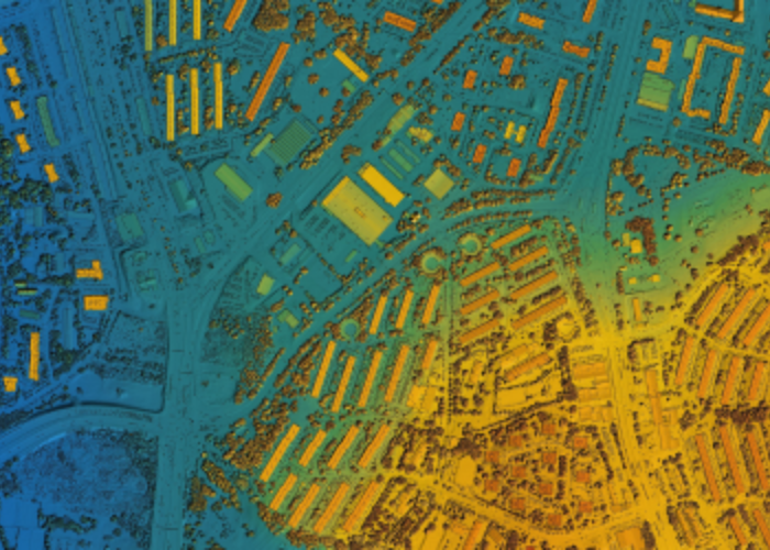
At Civitech, we understand the critical importance of spatial data in today’s complex world. Our GIS & Remote Sensing services are designed to leverage the power of geospatial technology, capturing, analyzing, and interpreting location-based information to extract valuable insights. Our team utilizes state-of-the-art tools and techniques, including satellite imagery, drones, LIDAR, and geospatial software, to collect and process data with unparalleled accuracy and precision.
The cornerstone of our GIS & Remote Sensing services lies in the ability to unlock invaluable insights from spatial data. We meticulously analyze complex datasets, uncovering patterns, correlations, and spatial relationships that might otherwise remain hidden. These insights provide a deeper understanding of geographical phenomena, enabling clients to make informed decisions across a myriad of sectors, including urban planning, agriculture, environmental conservation, disaster management, infrastructure development, and more.
Our expertise in GIS & Remote Sensing extends to advanced mapping techniques, allowing us to create detailed and customized maps tailored to specific project needs. Whether it’s mapping land use, assessing environmental changes, delineating boundaries, or analyzing terrain characteristics, our maps serve as powerful tools for visualization and decision support. These maps facilitate clear communication of spatial information, aiding in strategic planning and efficient resource allocation.
Moreover, Civitech’s GIS & Remote Sensing services are not limited to data collection and analysis. We specialize in translating complex spatial data into actionable insights and recommendations. Our team collaborates closely with clients, presenting findings in easily understandable formats such as interactive maps, reports, and visual representations. This enables stakeholders to grasp the significance of spatial data and make well-informed decisions that drive positive outcomes.
The impact of our GIS & Remote Sensing services transcends boundaries, contributing to improved efficiency, resource optimization, and better decision-making processes. We take pride in our ability to support projects that range from local community planning to large-scale infrastructure development, providing invaluable spatial solutions that lead to sustainable and impactful results.
Furthermore, at Civitech, we prioritize ethical considerations and data privacy, ensuring that our methodologies comply with industry standards and regulations. Trust, transparency, and the ethical handling of data remain at the forefront of our operations, establishing a foundation of reliability and integrity in all our GIS & Remote Sensing endeavors.
In conclusion, Civitech’s GIS & Remote Sensing services epitomize the convergence of cutting-edge technology, precise data analysis, and advanced mapping techniques. Through our innovative approach, we empower informed decision-making across various sectors by unlocking invaluable spatial insights. Partner with Civitech to harness the power of geospatial technology and transform complex spatial data into actionable intelligence that drives success and sustainability across diverse projects and industries.